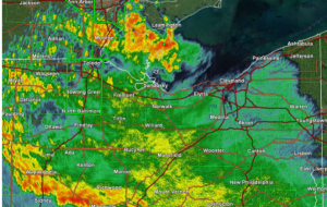
National Weather Service, Cleveland — A round of thunderstorms brought widespread flooding and some severe weather to many of our Ohio counties last night into early this morning. Another round of active weather is likely later today into tonight.
What to expect:
- Dangerously high heat index values in parts of Northwest and North Central Ohio, where Excessive Heat Warnings and Heat Advisories are in effect
- Ongoing flooding is expected to gradually recede as rain tapers off this morning
- Another round of showers and thunderstorms, potentially strong to severe, is likely between 5 p.m. and Midnight this evening
- Renewed flooding may quickly re-develop in areas that saw heavy rainfall and flooding Wednesday night or early this morning
What has changed:
- Flood Watch expanded to include all of northern Ohio and extended in time through 8 a.m. Friday
- A Slight Risk for both severe weather and excessive rainfall has been issued for this evening