by Dan Starcher | Aug 24, 2023 | Blog
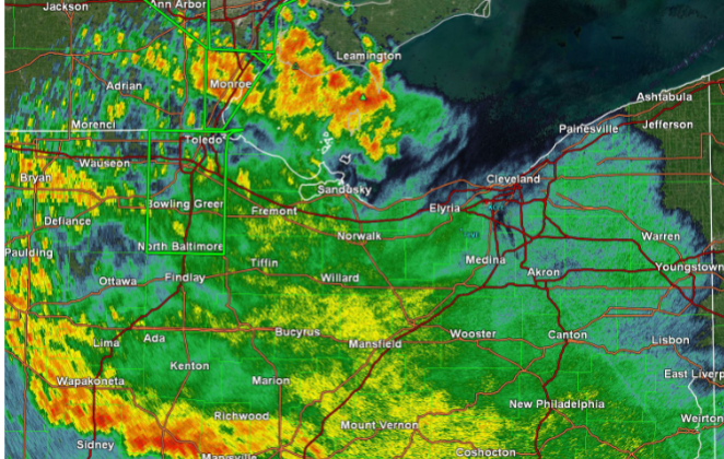
National Weather Service, Cleveland — A round of thunderstorms brought widespread flooding and some severe weather to many of our Ohio counties last night into early this morning. Another round of active weather is likely later today into tonight.
What to expect:
- Dangerously high heat index values in parts of Northwest and North Central Ohio, where Excessive Heat Warnings and Heat Advisories are in effect
- Ongoing flooding is expected to gradually recede as rain tapers off this morning
- Another round of showers and thunderstorms, potentially strong to severe, is likely between 5 p.m. and Midnight this evening
- Renewed flooding may quickly re-develop in areas that saw heavy rainfall and flooding Wednesday night or early this morning
What has changed:
- Flood Watch expanded to include all of northern Ohio and extended in time through 8 a.m. Friday
- A Slight Risk for both severe weather and excessive rainfall has been issued for this evening
DOWNLOAD PDF


by Dan Starcher | Feb 3, 2022 | Blog, Uncategorized
WAYNE COUNTY, OH, Feb. 3, 2022 — Due to inclement weather, Wayne County Government Offices will be operating on the following schedule, please check back for updates as they become available.
UPDATE at 8:30 a.m. on 2/4/2022:
- The Commissioners’ Office will be operating remotely.
- OSU Extension will be operating remotely.
- Treasurer’s Office will be closed.
- Job and Family Services will be operating remotely.
- Map Office will be operating remotely.
- Board of Elections will be closed.
- Recorder’s Office will be closed.
- Auditor’s Office will be closed.
- Building Code will be closed.
- Sewer and Water facilities staff will be operating.
- Child Support Office will be closed.
- Common Pleas, Juvenile, Probate, and Domestic Relations Court will be closed.
- Children’s Services building closed, staff working remotely.
- Municipal Court is closed.
- Health Department Offices are closed.
- Planning Dept. is working remotely.
- Title Office will be closed (plans to be open Saturday).
- Bureau of Motor Vehicles will be closed (plans to be open Saturday).
- Public Defender Office is closed.
***
UPDATE at 3:16 p.m. on 2/3/2022:
- Wayne County Sheriff has issued a Level 2 Snow Alert. Roadways are hazardous with blowing and drifting snow. Only those who feel it is necessary to drive should be out on the roadways. Contact your employer to see if you should report to work.
UPDATE at 9:05 a.m. on 2/3/2022:
- The Wayne County Administration Building is closed.
- Child Support Office is working remotely.
UPDATE 6:58 a.m.
- The Commissioners’ Office will be conducting business remotely.
- Child Support Office will be open.
- Auditor’s Office is closed.
- Treasurer’s office is closed.
- Recorder’s Office is closed.
- Bureau of Motor Vehicles is closed.
- CSEA is open with limited staff in office, some staff working remotely.
- Building Department is closed.
- Convention and Visitors Bureau is closed.
- Board of Elections is closed.
- Municipal Court is closed.
- Health Department is closed.
- OSU Extension is working remotely and answering phones.
- Map Office is closed.
- Title Office is closed
The list will be updated as the weather situation warrants it.
The National Weather Service (NWS) has issued a Winter Storm Warning for Northern Ohio beginning on Feb. 2 and ending on Feb. 4.
From the NWS:
An amplified upper-level trough will power a dangerous winter storm across the central and northeastern parts of the country over the next couple of days. This winter storm will bring a variety of winter weather hazards, including heavy snow, sleet, and freezing rain. The system will be prolonged with several rounds of winter weather lasting through Thursday for portions of the central U.S. before shifting to the interior Northeast.
The Salvation Army in Wooster has opened the warming shelter at 437 S. Market Street, Wooster. No appointment is necessary for those seeking shelter.
For immediate, non-emergency needs, questions, concerns, or reports contact the United Way of Wayne and Holmes Counties (UWWHC) WHIRE number, 330.263.6363. It will be answered from 8 a.m. to 5 p.m. and after-hour messages will be monitored and responded to as severity dictates. The UWWHC will be working closely with the Wayne County Emergency Management Agency (WCEMA) and the Holmes County Emergency Management Agency (HCEMA). For an emergency, dial 911.
To keep informed of the latest developments, sign up for the Wayne County Notification Service to get the latest information sent directly to your cell phone. The service is free of charge, but data rates may be charged by phone carriers. Follow this link to register: www.waynecountynotify.org.
Other useful links:
WCEMA Director Joe Villegas offered the following preparedness tips:
- Make sure that all electronic devices and battery back-ups are fully charged
- Have spare batteries on-hand
- Have enough prescription medication available
- Fill automobile gas tanks
According to Villegas, he has been contacted by area villages and cities and road crews are standing by and ready to go when needed. Andy Jones, Assistant Engineer at the Wayne County Engineers Office echoed Villegas, “We have all crews on standby and we are waiting to see how the weather situation develops,” he said. “Everything, right now, seems dependent on the high-pressure system, to determine if ice will form. We monitor the Ohio Department of Transportation’s (ODOT) ground temperature readings in real-time throughout the state, so we can get an idea of what is happening and react accordingly.”
Wayne County Road Crews:
- Have 23 trucks filled and ready to go
- Are making preparations for 12-hour shifts
- Are scheduling additional shifts, if necessary
- Have 38 drivers available and ready to go
- Maintain 1,000 lane miles of roadway
- Will react to the ice by adding grit (coarse sand) to the road salt
- Have 3,000 lbs. of salt available
Sheriff Travis Hutchinson will be monitoring road conditions and will issue the appropriate levels throughout the night and early morning hours. As always, if traveling, please allow extra time and give road crews extra distance. Many businesses and agencies are making alternative plans due to the weather, please call ahead to confirm appointments.

by Wayne Ohio | Feb 16, 2021 | Blog
WAYNE COUNTY, OH, Feb. 15, 2021 — The Wayne County Commissioners Office will be opening at 10 a.m. on Tuesday, February 16 due to the weather. Other county offices may be operating on a delay at their discretion.
by Wayne Ohio | Jan 30, 2021 | Blog
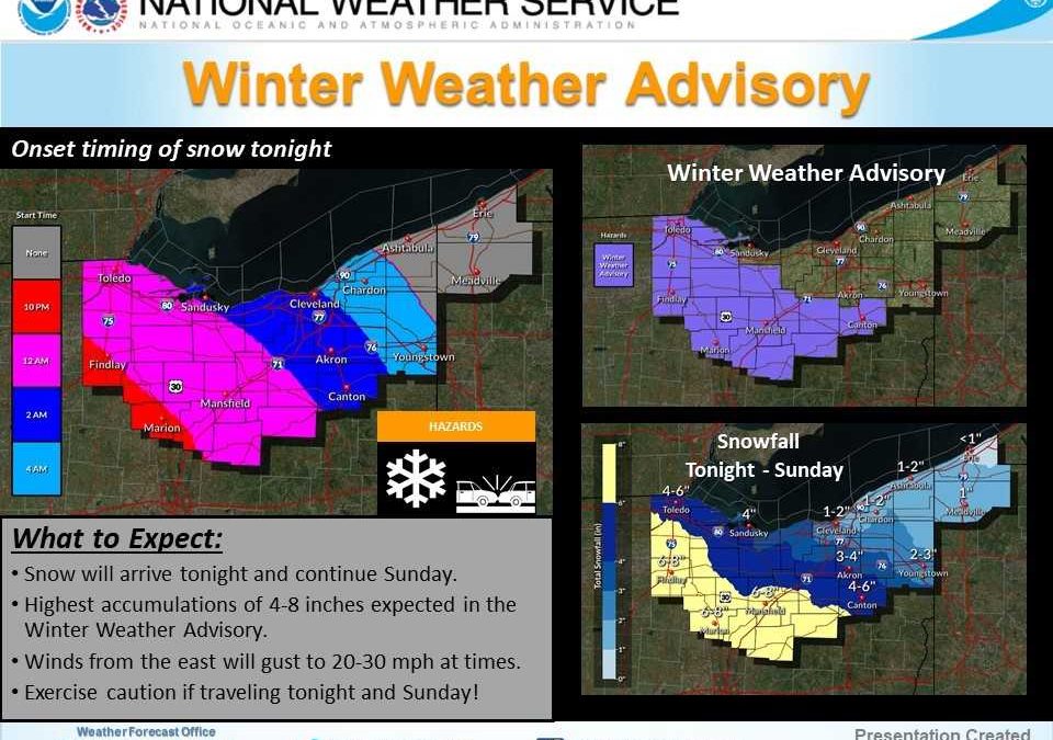
NWS CLEVELAND, OH, Jan. 30, 2021 — Snow will overspread the area from west to east tonight and continue through Sunday. The heaviest snow will fall from Midnight to Noon Sunday. Snowfall of 4 to 8 inches is expected in the Winter Weather Advisory with 1 to 4 inches possible outside of the Advisory. Light snow will continue Sunday night into Monday, especially for eastern areas. Locally higher snowfall amounts may be possible for areas from Findlay to Marion to Mount Vernon.
What has changed:
A Winter Weather Advisory has been issued for Lucas, Wood Ottawa, Sandusky, Hancock, Seneca, Wyandot, Crawford, Marion, Morrow, Knox from 10 PM Saturday – 7 PM Sunday.
A Winter Weather Advisory has been issued for Huron, Richland, Ashland, Wayne, Stark, Holmes from 1 AM – 10 PM Sunday.
The following links can be bookmarked for the latest information:
Winter Storm details can be found HERE.
Additional information and snowfall graphics can be found at www.weather.gov/cle/winter.
Download a copy of this report HERE.
by Wayne Ohio | Apr 6, 2020 | Blog
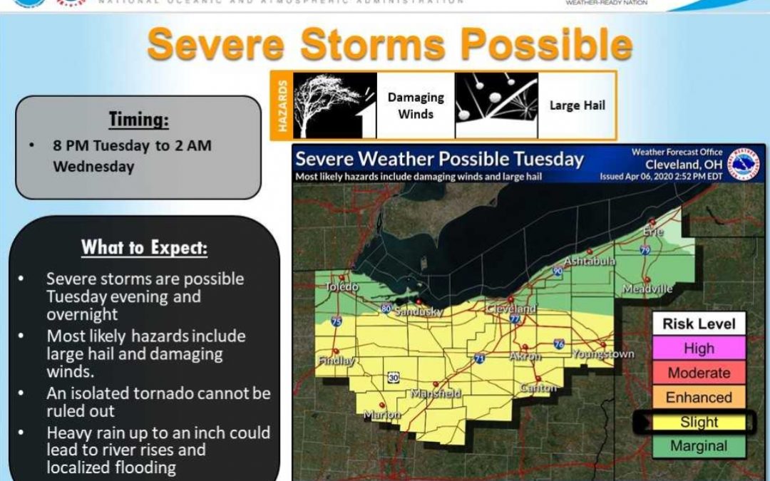
NWS IN CLEVELAND, OH, Apr. 2020 — What to expect:
- Several rounds of showers and thunderstorms are possible which will bring large hail, damaging wind, and heavy rain.
- The first round of showers and thunderstorms will occur tonight through tomorrow morning.
- The primary threat for this round is heavy rain, although hail and gusty winds are also possible.
- Confidence is high on the timing and location of this initial round of storms.
- Areas most at risk will be west of I-77 and north of US-30.
A break in storm activity is expected throughout much of the day Tuesday (late morning through the afternoon). The second round of showers and thunderstorms will occur Tuesday evening and overnight. Confidence remains low in storm coverage and location, but storms that do develop are likely to become severe, capable of large hail, damaging winds, heavy rainfall, and an isolated tornado. Areas most at risk include much of Northern Ohio.
Posted by Dan Starcher, public communications specialist for the Wayne County government.